Posts by: Andrew Thompson
-
Recently, I was working with an utility company that wanted to use CartoDB as a web mapping platform replacement for the way they currently generate maps of their physical infrastructure: AutoCAD.
-
With the news that Google is shuttering its Google Maps Engine product (GME) in less than a year, many new clients have come to CartoDB in search of a “new home” for their geospatial needs. For organizations still looking at migrating from GME to CartoDB, our partners over at CloudSherpas have covered in detail both “why” CartoDB is a great choice and the technical “how” of the transition (hint: it’s easy!). But any large organizational software migration can be challenging to wrap one’s head around, which is why we wanted to go a step further and compare, 1-on-1, some common workflows and uses of GME (right from the GME documentation) and how one would accomplish those same tasks within CartoDB. Read on to discover just how easy it can be to move to CartoDB!

-
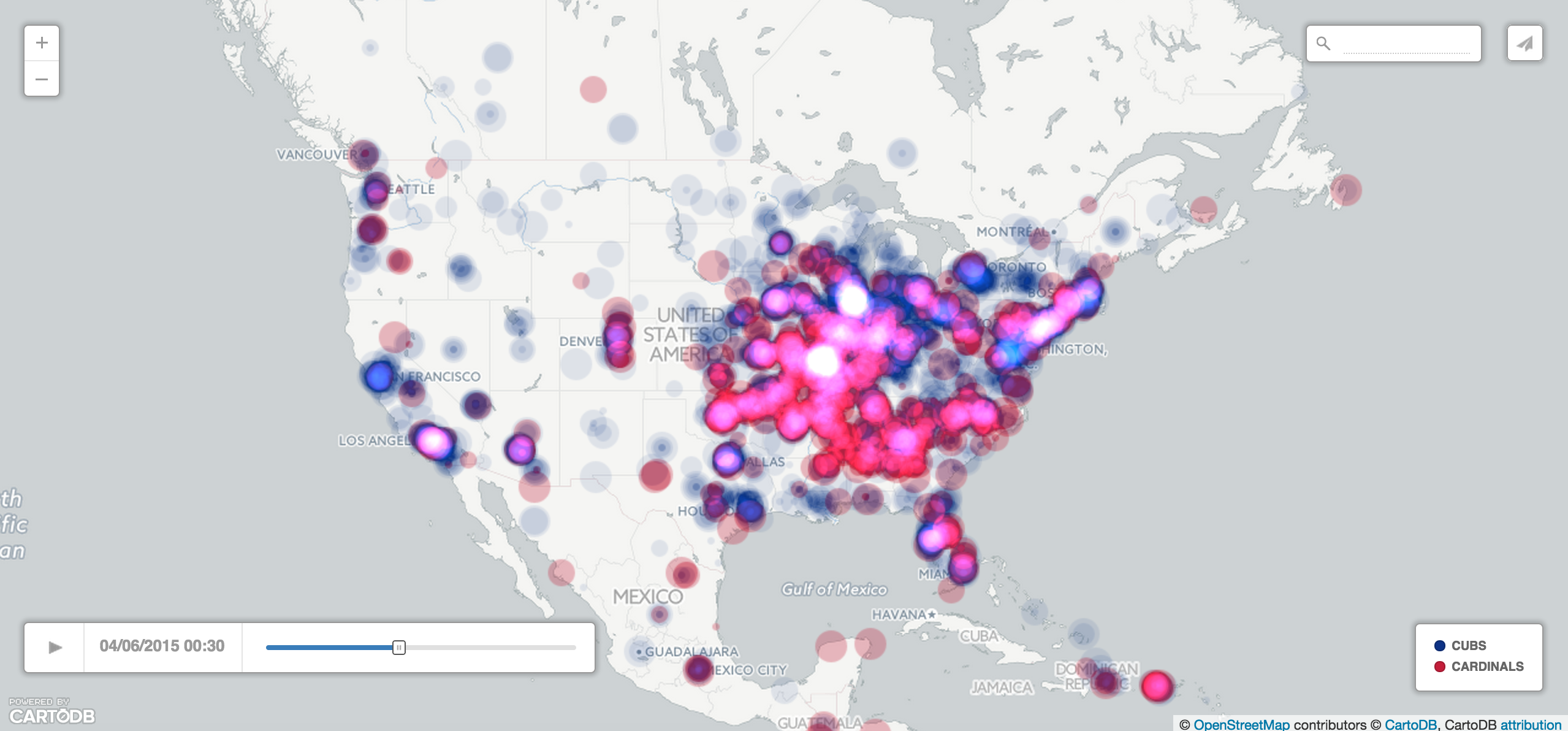
Many things herald the long-awaited arrival of spring - sunnier weather, leafier trees - but no springtime event is more exciting to baseball fans than Opening Day! On an appointed day in April, all 30 Major League Baseball teams open the new season enthusiastically with 15 back-to-back ball games.
While our Madrid office tends to pay more attention to another kind of “‘bol” sport, this year’s MLB Opening Day was super exciting for us in CartoDB New York because MLB asked us to create a series of Twitter maps for each and every opening day game! How often does baseball and cartography collide?! Mapping Tweets for each team’s hashtag during their game turned out to be a great way to visualize the ferverous excitement of fans and even uncover some interesting stories. Take a look at what we found!
-
“How many layers does CartoDB support?” It’s a question we hear often. The word “layer” has been a part of the GIS nomenclature since the times of John Snow, and the geospatial community is used to thinking in terms of layers. Many of the prevailing desktop GIS software packages support this mode of thinking with “layer browsers” that have checkboxes for roads, parks, tax lots, pipes - in short, each and every type of dataset in the user’s project.
Aye, but there’s the word: dataset! A “layer” is often really just a dataset. Nothing more, nothing less. In a relational database environment, like CartoDB, individual datasets are stored as tables. And since PostgreSQL (and therefore CartoDB) can support thousands and thousands of tables of data, the answer to “how many layers does CartoDB support?” is pretty much as many as you would like! If you need to, this makes creating a “geoportal” site to all your organization’s geospatial datasets no problem at all.
-

To say SharePoint is a popular enterprise software platform is a bit of an understatement. Having evolved over 15 years, SharePoint is used by over three quarters of the Fortune 500 and over 100 million users in all. SharePoint is often described as a document-sharing, intranet, and business collaboration platform, but really its functions are as varied as the organizations that use it.
As CartoDB grows in popularity with companies as a fully-featured enterprise geospatial platform itself, it was only a matter of time before our users would want to combine their CartoDB maps with their Sharepoint sites. They work together splendidly, we’re pleased to say, and we have recently published a short 10 minute tutorial on how to share your visualizations through Sharepoint. Enjoy!
