Flying Around the World with CartoDB
by  Paul Ramsey
As a child, nothing was more exciting to me than a chance to ride on an airplane. And after enjoying playing with the seatbelt buckle and feeling the crazy push of take-off acceleration, I would usually settle in and page to the back of the in-flight magazine where the airline route maps were: where were we going today, and where could we go tomorrow?
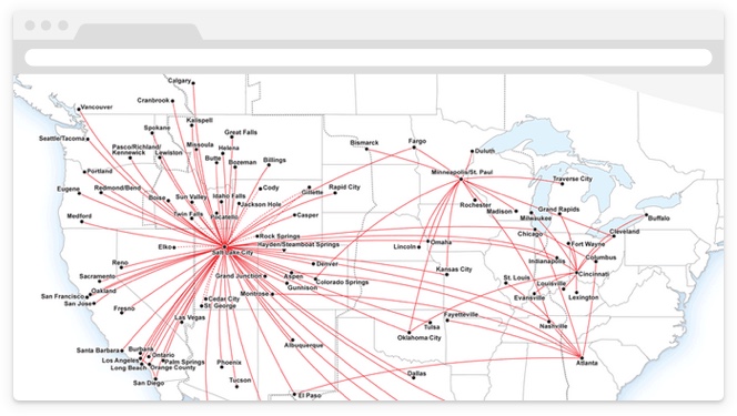
Destination Map
We can build route maps for any city in the world using airport and route data from OpenFlights.org. Start by uploading the airports.csv and routes.csv files
into CartoDB.
We can see every destination available starting from Vancouver, Canada (airport code “YVR”) by making some custom SQL to join the airports table to the routes table and restricting to just the “YVR” routes:
SELECT a2.cartodb_id, a2.the_geom_webmercator, a2.city, r.airline
FROM airports a1
JOIN routes r ON r.airport_st = a1.code_iata
JOIN airports a2 ON r.airport_end = a2.code_iata
WHERE a1.code_iata = 'YVR' AND r.codeshare IS NULL
That’s the data we want, but without the flight lines it lacks a sense of movement.
Simple Route Map
Our query is already joining the airports twice: once for the origin and once for the destination airport, so we can turn the end points into a line very easily using the ST_MakeLine() function:
SELECT a2.cartodb_id,
 a2.city, r.airline,
 ST_Makeline(a2.the_geom_webmercator, a1.the_geom_webmercator) as the_geom_webmercator
FROM airports a1
JOIN routes r ON r.airport_st = a1.code_iata
JOIN airports a2 ON r.airport_end = a2.code_iata
WHERE a1.code_iata = 'YVR' AND r.codeshare IS NULL
That looks much better! But there’s something wrong about this map – actually two things wrong.
First, the routes are all straight lines, and they should be great circle routes, that’s how the airplanes fly!
Second, some of the routes go the wrong way around the world: no airline would fly from Vancouver to Sydney via Africa!
Great Circle Route Map
If we convert our lines into great circle routes, we can maybe kill both of these birds with one stone, since the great circle routes will go the right direction.
SELECT a2.cartodb_id,
 a2.city AS city, r.airline,
  ST_Transform(
     ST_Segmentize(
         ST_Makeline(
           a2.the_geom,
           a1.the_geom
         )::geography,
         100000
     )::geometry,
     3857
   ) as the_geom_webmercator
FROM airports a1
JOIN routes r ON r.airport_st = a1.code_iata
JOIN airports a2 ON r.airport_end = a2.code_iata
WHERE a1.code_iata = 'YVR' AND r.codeshare IS NULL
This is a bit complex, but reading the nested functions outwards starting from the ST_MakeLine(), we:
- Cast the point-to-point line to the “geography” type, which understands edges (also known as connections between nodes) as great circles; then
- Use the
ST_Segmentize(geography)function to add points to the line along the great circle (so when we put it back on the flat map, it’ll appear curved); then - Cast the line back into the “geometry” type we use for flat mapping; and finally
- Transform the coordinates of the line using
ST_Transform(geometry, srid)to the web mercator projection we use on our flat maps.
The end result is really, really close!
But what is going on with those horizontal lines?
Great Circle Route Map with Dateline Fix
There’s a gap, right where the horizontal line appears.
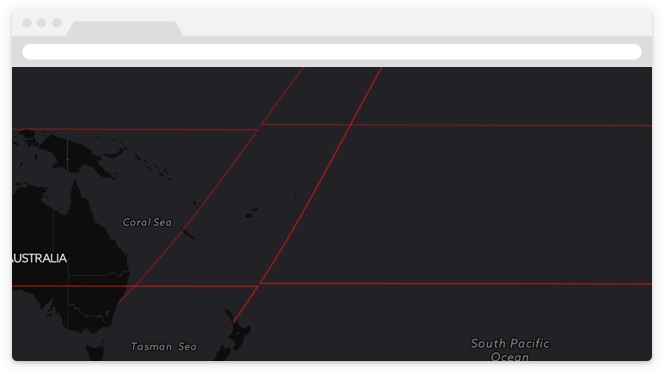
Everything is fine until an edge on the great circle route tries to cross the dateline. Then it zings around the world in order to hook up to the next edge. Fundamentally our map still does not understand the circularity of the world, even though the edges we built do understand it. We have to work around the limitations of the flat map, by chopping our data at the dateline to avoid having edges that cross it.
-- First build our lines just as before, this can be any raw data you
-- need to feed into a dateline chopping process
WITH lines AS (
  SELECT a2.cartodb_id,
  a2.city, r.airline,
  ST_Segmentize(ST_Makeline(a2.the_geom, a1.the_geom)::geography,100000)::geometry as the_geom
  FROM airports a1
  JOIN routes r ON r.airport_st = a1.code_iata
  JOIN airports a2 ON r.airport_end = a2.code_iata
  WHERE a1.code_iata = 'YVR' AND r.codeshare IS NULL
),
-- Now break the input data into two sets, one to split and one to leave
-- unprocessed. Objects that cross the dateline will appear to be very wide
-- (as they zing across the world) so we'll only chop features that are very
-- wide. This is just for efficiency.
tosplit AS (
  SELECT * FROM lines
  WHERE ST_XMax(the_geom) - ST_XMin(the_geom) > 180
),
-- Narrow objects we'll leave un-chopped.
nosplit AS (
  SELECT * FROM lines
  WHERE ST_XMax(the_geom) - ST_XMin(the_geom) <= 180
),
-- In order to chop the objects we need to get them into a space where they make
-- "sense" so we shift any vertex that is < 0 to the right by 180 units,
-- effectively building a map ranging from 0 to 360 units centered around the
-- dateline, instead of the usual map from -180 to 180 centered at Greenwich.
-- Then if we split at 180, we get a nice cut, just where we want it.
-- We split by removing a very narrow gap from the objects, centered at 180, wide
-- enough so that we don't get any wee rounding errors at the dateline.
split AS (
  SELECT
    cartodb_id,
    city, airline,
    ST_Difference(ST_Shift_Longitude(the_geom),
                  ST_Buffer(ST_GeomFromText('LINESTRING(180 90, 180 -90)',4326),
                            0.00001)) AS the_geom
  FROM tosplit
),
-- Merge the split features back with the unprocessed features.
final AS (
  SELECT * FROM split
  UNION ALL
  SELECT * FROM nosplit
)
-- Transform them all into web mercator for mapping.
-- The web mercator map projection handles the longitudes > 180 as if they were
-- negative longitudes, so there is no need to convert them back.
SELECT
  cartodb_id,
  city, airline,
  ST_Transform(the_geom,3857) AS the_geom_webmercator
FROM final
And it works!
Of course, this is a route map of all flights leaving Vancouver (YVR), so it’s not exactly the kind of map you’d find in a in-flight magazine. However, it’s easy to build such a map, just by changing set of input airports we use to build
the routes.
Where the existing query says:
WHERE a1.code_iata = 'YVR' AND r.codeshare IS NULLReplace the airport filter with an airline filter of “AC” to get an Air Canada route map:
WHERE r.airline = 'AC' AND r.codeshare IS NULLOr try “UA” for a United map, or “DL” for a Delta map.
Happy flying!