-
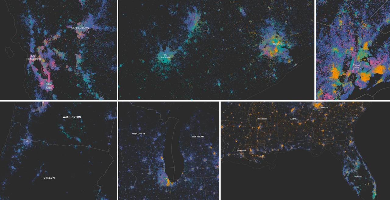
This map shows the distribution of people in the US who have a problem with both their sight and their hearing. It was made using US Census data but if you go looking for sight and vision data in your copy of the US Census files, you aren’t going to find them. How did we make it? In this post we will take you through a quick experiment in using a pinch of public use microdata, a smidgen of machine learning and some inspiration from our friends over at Enigma, to make the US Census reveal to us patterns we’ve never seen before.
-
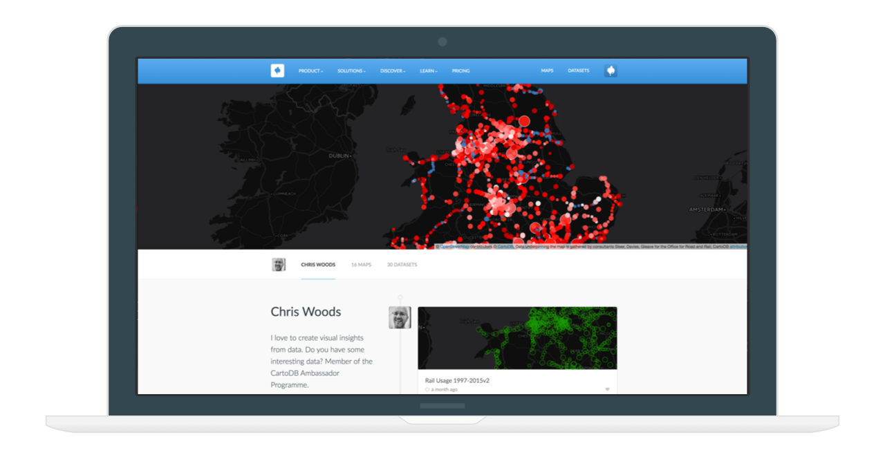
At CartoDB we do our very best to spread the word on how anyone around the globe can leverage data and visualizations to make better, faster decisions. When great mappers make and discover insights through location intelligence we like to reward them.
We are proud of our carefully selected and very talented CartoDB Ambassadors. CartoDB Ambassadors are deeply involved in the mapping community and are inspirational educators that use CartoDB technology to empower future mappers. Ambassadors play an essential role to our mission of democratizing location intelligence by producing amazing maps using open data and educating others about the power of CartoDB.
-

Are you ready to look at maps in an unorthodox way and expand your cartographic horizons? The “Creative Cartography and Beers on March 11, in Paris, will do just that. And more importantly, seek to establish bridges between mapping and other fields - particularly creative coding and design.
-

Everything happens somewhere and CartoDB understands that location intelligence is everywhere. Where is the intersection of everything and everywhere? The simple answer is location intelligence, a market that CartoDB leads. We know that the location intelligence market is rapidly changing, with 80% of data having a location component, but only 10% of organizations and companies making use of it. CartoDB wants to change that.
-

This month we announced our acquirement of Nutiteq, a leader in SDK development for all mobile platforms, and our latest innovation, Deep Insights, for unprecedented big data analysis at any scale. In March, we want to continue to help you go further with location intelligence and CartoDB.
-

Using CartoDB.js and the CartoDB Platform, you get the best of both worlds: powerful GIS technologies with no setup required combined with the complete freedom provided by the HTML5 stack.
It’s so addictive in fact, that at some point you’ll be building a ton of interactive maps without even realizing it. And inevitably, you will end up doing a few repetitive tasks every time: creating boilerplate files, importing JavaScript libraries, setting up a local web server, etc…
-
Onix is a leading provider of IT solutions and services to a broad range of government and corporate customers. Onix partners with location intelligence industry leaders such as CartoDB and offers extensive expertise in the design and implementation of end-to-end comprehensive IT solutions.
-
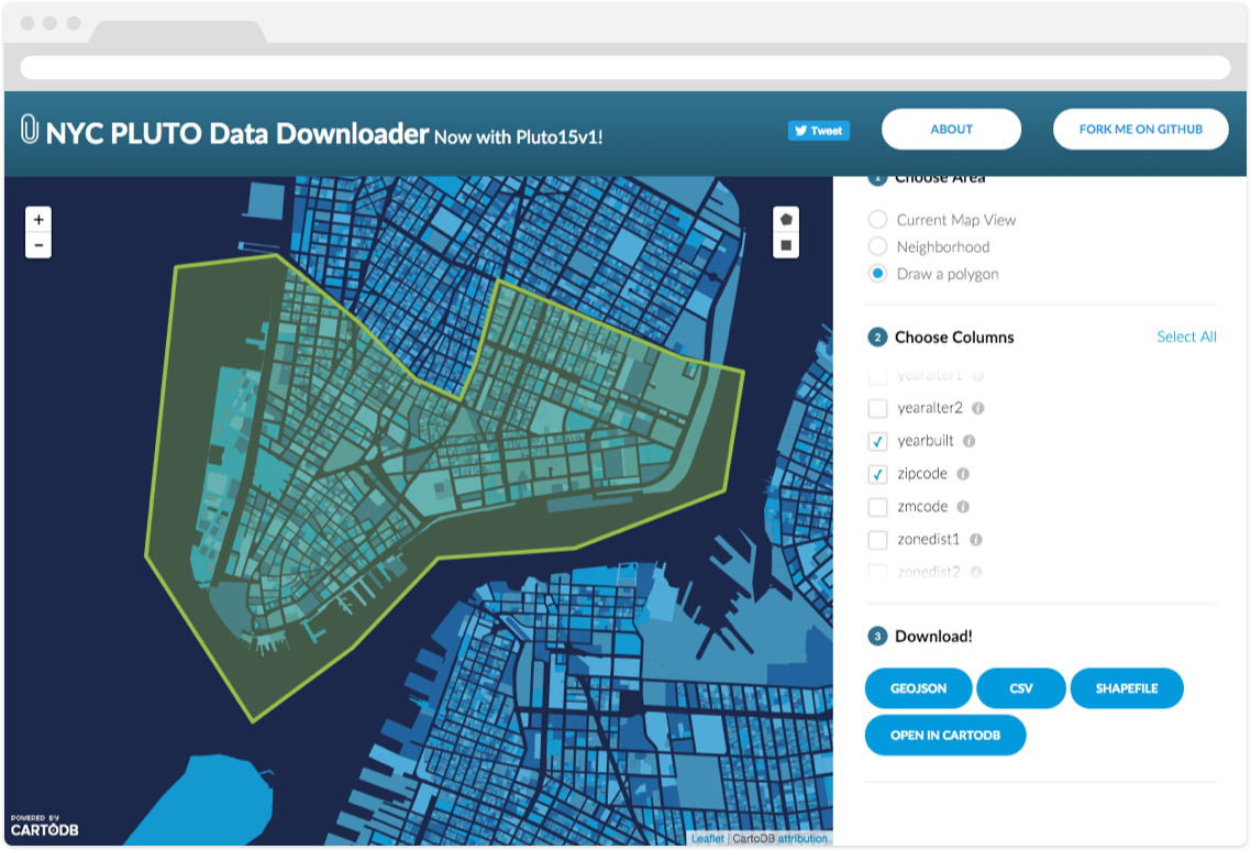
As more governments and businesses are adopting proactive open data policies and programs, the infrastructure of data publishing is becoming increasingly important. The time-honored tradition of publishing file-based machine-readable data on the web is still alive and well, but live, api-accessible databases can help when publishing data that is updated frequently, or is so large that publishing it as files becomes inefficient. Luckily for you, if you have a CartoDB account, you already have a live, api-accessible database at your disposal! Read on to learn how CartoDB can help make your open data shine.
-
 Location intelligence is an often heard term, but what it means and how it can benefit businesses, institutions and individuals may not be immediately obvious. Location intelligence is more than analysis of geospatial information or geographic information systems alone, it is the capability to visualize spatial data to identify and analyze relationships. Evolving from GIS, location intelligence provides analytic and operational solutions across organizations.
How does all this data help people, and what about the customer or client? Organizations have discovered that data can be one of the best ways to get insights about customers and how to serve them better, increasing brand loyalty and improving customer relationship management. Linking customer addresses to a geographic area and then running these against internal company data and external demographics such as census data and income data, or other open data can provide unprecedented levels of detail. Who people are, what they do, and how and when they consume is tied to the where in essential ways. What is their neighborhood, commute, and workplace?